About Michael Hill

Wreningham Parish Council Chair

Reference: 2018/1863
Applicant: Mr Raymond Turner
Location: Land Adj To Fairlands Top Row Wreningham Norfolk
Proposal: Reserved matters application for appearance, landscaping, layout and scale following outline permission 2017/2828 for single storey domestic dwelling and garage to include access.

Copies of the submitted plans can be viewed on-line

Please return comments quoting reference 2018/1863 by 20 September 2018 via:
e-mail: planning@s-norfolk.gov.uk , or,
Mail: South Norfolk Council, South Norfolk House, Cygnet Court, Long Stratton, Norwich NR15 2XE


Ashwellthorpe Road, Church Road, Mill Lane, Wymondham road

I have just received the following advance warning about roadworks in the village.

Church Road, Wreningham, Norfolk
03 September — 06 September
Delays likelyRoad closure
Works location: Jnc Wymondham Rd TO Glebe Close, Church Rd, Fundenhall, Norwich NR16 1DP
Works description: Access required to BT under ground structure for cabling, jointing and Desilt works no excavation work involved.
Responsibility for works: Openreach
Current status: Planned work about to start
Works reference: BC005CA1W00000IBB9C2FW01

Ashwellthorpe Road, Wreningham, Norfolk
03 September — 06 September
Delays possibleTraffic control (multi-way signals)
Works location: Jnc Ashwellthorpe Rd and Mill Lane Rd, Wreningham, Norwich NR16 1AU
Works description: Access required to BT under ground structure for cabling, jointing and Desilt works no excavation work involved.
Responsibility for works: Openreach
Current status: Planned work about to start
Works reference: BC005CA1W00000IBB9C2FW02

Mill Lane, Wreningham, Norfolk
03 September — 06 September
Delays possibleTraffic control (multi-way signals)
Works location: Jnc Mill Ln and Ashwellthorpe Rd, Wreningham, Norwich NR16 1AN
Works description: Access required to BT under ground structure for cabling, jointing and Desilt works no excavation work involved.
Responsibility for works: Openreach
Current status: Planned work about to start
Works reference: BC005CA1W00000IBB9C2FW04

Wymondham Road, Wreningham, Norfolk
03 September — 06 September
Delays possibleTraffic control (multi-way signals)
Works location: Jnc Wymondham Rd and Church Rd, Wreningham, Norwich NR16 1AZ
Works description: Access required to BT under ground structure for cabling, jointing and Desilt works no excavation work involved.
Responsibility for works: Openreach
Current status: Planned work about to start
Works reference: BC005CA1W00000IBB9C2FW03


Monday’s meeting had a lively and informative Open Forum during which many of the 116 parishioners present expressed their views about the planning application for the field adjacent to the Village Hall. The Parish Council was given invaluable feedback and observations. In attendance were Phil Hardy (District Councillor) and Colin Foulger (County Councillor).

Prior to the meeting the EDP carried the story. This was followed by an update at the close of the meeting.

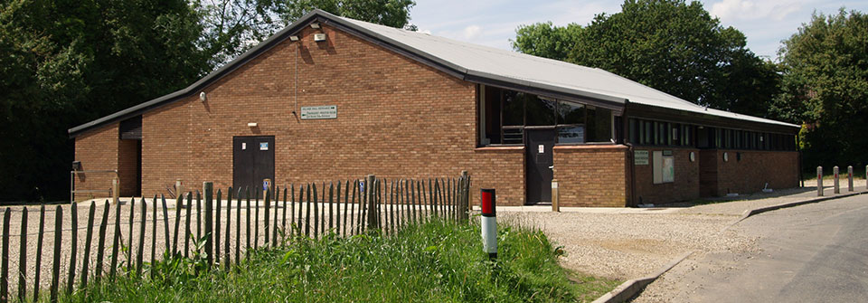
Never before have I seen such long queues waiting to attend a Parish Council meeting! As the hall filled, the Parish Council took up position on the stage in order that parishioners could see and hear  clearly.

A show of hands indicated full support to oppose the application. Parishioners had clearly shown they wanted the Parish Council to register an objection with South Norfolk.

People reported difficulties using the SNC planning site when trying to register their comments: they ran out of time; lost their work; were unable to complete registration; etc. With this in mind, the District Councillor has arranged for the consultation closure date to be put back to 24th August. For those concerned about their names and address being made public, Councillor Hardy invited them to email their comments to him. He will collate them for inclusion in his Councillor’s report. I must emphasise that this does not carry the same weight as individual comments to South Norfolk Planning.

Before the meeting, I had taken informal legal advice which recommended delaying any legal intervention until the planners had made their recommendation. The Parish Council may then instruct a solicitor.

Two thirds of parishioners expressed support for a separate legal approach sourced and funded by themselves.

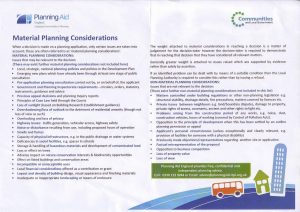
I need to stress that the main message, underlined by Colin Foulger, is that comments must be objective, factual and address material considerations, as explained in the image below. Colin makes it clear that if people ensure sufficient comments are made then there is a very good chance that we will win.

Finally, I wish to thank all who attended for their positive approach and working with me as the Chair to ensure the meeting met its objectives. And, thank you to those who helped to clear away the tables and chairs.


Planning Application – Field next Village Hall, Mill Lane

SNC have extended the consultation by a week following complaints that their website had problems when people tried to register for comments. The new date is 24th August.

Reference: 2018/1658
Applicant: Miss Naomi Todd
Location: Land Adj To Wreningham Village Hall Mill Lane Wreningham Norfolk
Proposal: Change of use to stable to day room, standing of 1 mobile home, 2 tourers and 3 concrete pads

Comments to South Norfolk Council by 24 August 2018 quoting reference 2018/1658 via:
e-mail: planning@s-norfolk.gov.uk , or,
Mail: South Norfolk Council, South Norfolk House, Cygnet Court, Long Stratton, Norwich NR15 2XE


It’s almost here, but for the rain! The long heralded archaeological training event by Steve Hickling (contact: steve.hickling@norfolk.gov.uk) is rescheduled form a wet Sunday to a, hopefully dry, Tuesday evening 7 August at 7pm in the playing field. Come along, find out what it is all about and watch, even if you have not yet identified a 1m square to dig out (or don’t intend to!).

TP training poster

This the training for the real thing over the weekend of 11/12 August.


NCC have sent us notice of a temporary closure on part of Church Road from 13th to 24th August. Please see the official documentation below:

  1. The Order – This allows the Traffic Authority (Norfolk County Council) to temporarily restrict or prohibit the use of a road and/or footpath.
  2. The ‘Propose To’ Notice (PT)– This is the public Notice we must advertise at least seven days before making an Order.
  3. The ‘Has Made’ Notice (HM)– This is the public Notice we must advertise within 14 days of making an Order.

The proposed order comes into effect on the date shown. The date on the notices is when they will appear in the Eastern Daily Press.  If we have to change any dates, we will let you know.  If you have any questions about the order and notices, please contact Alison Wilton on (01603) 222591 or Jennifer Batten on (01603) 223673. If you have any questions about the work, please contact the Area Highways Office on the number given on the notices.

Alison Wilton, Legal Officer (Traffic Orders), nplaw
Tel: (01603) 222591
Fax: (01603) 222899
alison.wilton@norfolk.gov.uk


An extra Parish Council meeting to discuss this application has been arranged for Monday July 23, at 7.30pm in the Village Hall, Social Club. Public are welcome.

Reference: 2018/1431
Applicant: Mr & Mrs Will & Rachael Lockwood
Location: Land West Of All Saints Church Church Road Wreningham Norfolk
Proposal: Five self/custom carbon negative homes

Copies of the submitted plans can be viewed on-line here.

Comments on this application to be with SNC by 23 July 2018 via:
e-mail: planning@s-norfolk.gov.uk , or,
Mail: South Norfolk Council, South Norfolk House, Cygnet Court, Long Stratton, Norwich NR15 2XE


We have an email from the GNLP (Greater Norwich Local Plan) team advising on additional sites being proposed for development. Comments from Parishioners and Parish Councils will not be received until later in the year. Only those areas which have a change to the last GNLP consultation have a site “map book”. Wreningham has one: Wreningham CP_mapBook.

The e-mail text is below:

Additional potential sites put forward for Greater Norwich Local Plan

You will be aware that there was a Regulation 18 consultation between January and March this year for the Greater Norwich Local Plan (GNLP). During this consultation, additional sites were proposed by landowners, agents and developers for possible future development and some of the previous site boundaries were revised. Approximately 200 additional or revised sites have been put forward throughout the three districts of Broadland District Council, Norwich City Council and South Norfolk Council. In addition, small sites below 0.25ha, which were not subject to the Regulation 18 consultation, will need to be considered by us in the context of potential changes to settlement boundaries.

There will be another Regulation 18 consultation later this year (probably starting in October) during which the parish council and your residents will be able to make comments on the additional and revised sites and settlement boundary proposals. Until this time there is no mechanism for recording comments against sites, but we wanted you to have as much time as possible to consider sites put forward in your parish. The information about the additional sites, revised sites, and proposals to change the settlement boundaries has been published on our website at the following link:

http://www.greaternorwichgrowth.org.uk/planning/greater-norwich-local-plan/reg-18-consultation-sites-2018/

At this link you will find a schedule of sites and associated map booklets for each parish. The schedule is sorted by district then parish, and sets out the unique reference number for each site, its location/address, and provides details of the proposed development. The map booklets are arranged by parish and show the boundaries of each site alongside the unique reference number. Only parishes containing sites which are new, revised, or proposed changes to settlement boundaries have a map book.

A few key points should be noted about the latest publication of sites:

  • There has not yet been any analysis of the sites newly submitted or revised, and further work is needed to identify constraints, and whether any such constraints can be overcome. Therefore no assumption can be drawn as to the acceptability (or otherwise) of any sites.
  • Far more land has been submitted for consideration than will be needed. Many sites will be inappropriate for allocation due to unresolvable constraints (such as landscaping, flood risk, poor access to services etc) and others, whilst not unacceptable in principle, will be less suitable for allocation than “competitor” sites. Growth will be carefully planned to ensure it is located in the most appropriate locations, and will be supported by appropriate and timely infrastructure provision.
  • The current long list of sites will be refined. Some sites, or parts of sites, have been submitted twice, once by the landowner and once by a land promoter. Some sites already allocated in adopted local plans have been re-submitted (perhaps with requests for changes to adopted policy clauses, or a different mix in the development type proposed), so are not ‘new’ sites per se.
  • It is also likely that further sites will be promoted during the production of the GNLP. This is a somewhat iterative process.
  • It will not be until the full public consultation programmed for late this year that the HELAA analysis of all sites will be made available.